

Salzburg Live Laboratory
New innovation projects can be instigated and supported through the basic services, for example such as networking of stakeholders, marketing and awareness-raising. These test your new services, products or systems in the live laboratory environments of the test corridors or Stations 4.0. zukunftswege.at also provides various mobility and basic data for these live laboratory environments. These come either directly from the regional authorities responsible (basic data) or are generated from one of the services provided in the project. Access to the services is also possible without use of the physical infrastructure of the live laboratory environments.
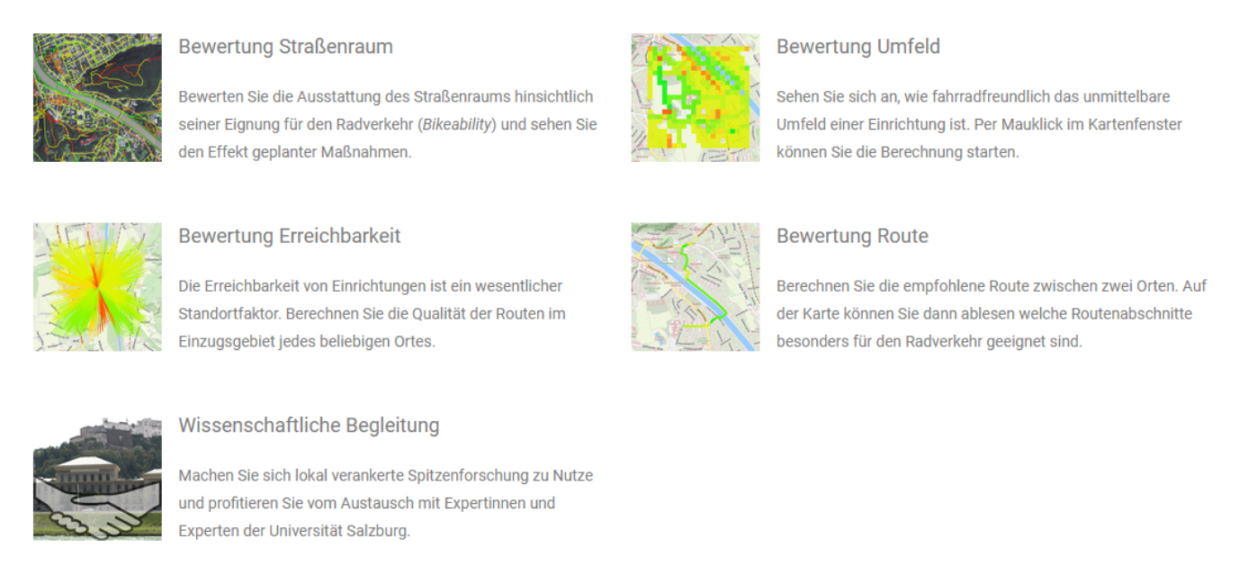
Special Services
- Bike quality
- Bikeability and data integration
- Customer journey
- Documentation and data platform
- Cycle mobility
- Stations 4.0
- Cooperative transport hubs
- Route analysis
- Traffic data for private/public transport
- Walkability
Data Infrastructure
- Data from the services
- Basic public transport data
- Basic private transport data
- Basic non-motorised private transport data
- Spatial structure data
Physische Infrastruktur
- Testkorridor Stadt Salzburg
- Testkorridor Stadt Salzburg – Neumarkt
- Testkorridor Stadt Salzburg – Freilassing
- Testkorridor Stadt Salzburg – Bad Reichenhall
- Haltestelle 4.0 Neumarkt
Basic Services
The networking activities included in the basic functions continuously activate and network significant stakeholders that are relevant to mobility in the various specialist areas.
This should aid with the ongoing exchange of experience and the transfer of knowledge and innovation. Collaborative processes are also encouraged in all innovation projects. In the context of awareness-raising for sustainable mobility systems, users and citizens are involved through innovative planning and development processes.

Awareness-raising and knowledge transfer
External representation and highlighting of zukunftswege.at
Acquisition and basic advice from innovation projects
Communication with stakeholders, the specialist community, industry and business
Networking of stakeholders
Strategy to develop cross-border data bases
Special Services
We Support Projects with Special Databases
Our research partners offer special services from their research developments. Business and industry can therefore use specific data for their projects, which are currently available only in our test environments.
With your project, if you are interested in using one or more of the services listed below, please contact us directly via our Cooperation Request.
- Bikeability
- Bike Quality
- Customer Journey
- Cycle Mobility
- Documentation and Data Platform
- Real Traffic Data
- Route Analysis
- Station 4.0
- Traffic Data for Private/Public Transport
- Transport Hubs
- Walkability
Bikeability
Special Focus on Active Mobility
For the purpose of balanced consideration of the environmental alliance, particular attention should be paid to active mobility; the University of Salzburg has developed the Bikeability service to this end.
Cycle traffic has the potential to act both as a substitute for short journeys and as a feeder for local public transport. The Bikeability index expresses the suitability of road sections for cycle traffic. The calculation is based on data that are typically available on transport graphs. In coordination with other services, the Bikeability index is prepared or the test corridors and provided for innovation projects. The interoperable and transferable Bikeability index is referenced as an attribute on a corresponding transport graph and can be used as the basis for various analyses.
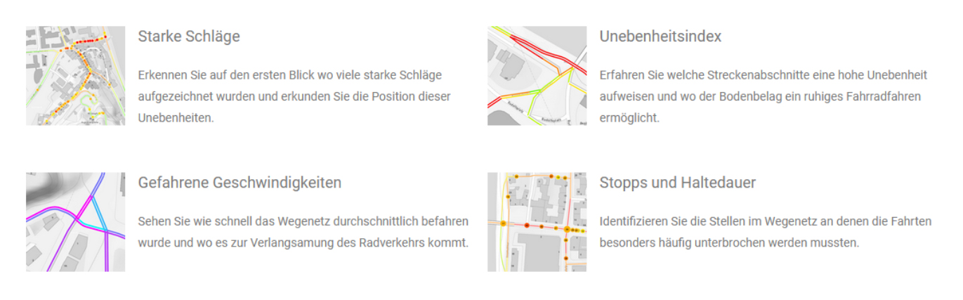
Bike Quality
Quality measurement of cycling infrastructure
For environmental conservation and sustainability, the bicycle is the best mode of transport for short to medium distances. To increase the proportion of cycle traffic and contribute to the achievement of climate objectives, targeted measures are needed to expand and improve the existing cycling infrastructure. With Bike Quality, Salzburg Research employs digital technologies to identify areas with the greatest need for action in a cycle path network.
With Bike Quality, quality parameters of the cycling infrastructure can be measured. This gives the transport planning a neutral decision-making basis for future plans and targeted improvement of the cycling infrastructure. Investments to improve the cycling infrastructure can therefore be made in a targeted way and the appeal of cycling can be enhanced.
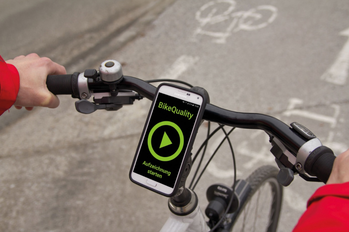
A smartphone attached to the handlebars records vibrations and bumps during the journey. As well as surface quality, speed and typical stops are also identified together with the stop duration. All the recorded data are referenced on a digital road graph (graph integration platform – GIP).
As part of the zukunftswege.at project, the data-driven evaluation is being expanded to the cycling infrastructure of the test corridors. For the first time, this means that the ride quality of the principal cycle paths from the surrounding area into the city of Salzburg is being assessed along the test corridors. The data set created is available for other innovation projects.
Furthermore, this service is being developed, so that a high-precision sensor (XSens MTi 680G) rather than smartphone-based recording is used for the data acquisition. The Sensor is also available for use in innovation projects.


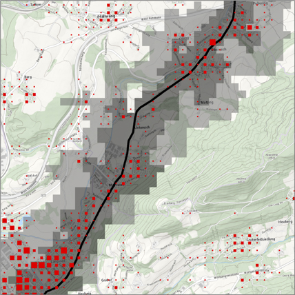
Figure 1: Results of the quality measurement of cycling infrastructure, © Salzburg Research
Figure 2: A smartphone is mounted on the handlebars and the data acquisition for evaluation of the quality measurement of the infrastructure uses the Bike Quality App. © Salzburg Research
Figure 3: XSens (sensor) mounted on a helmet for data recording, © Salzburg Research
Customer Journey
Findings for innovation projects are provided in a methodical or data-related way.
The customer journey should be analysed and visualised for representative customers (commuter/leisure cyclists, tourist journeys) for continuous route strings, and the findings should then be provided for innovation projects in a methodical or data-related way. Coupled with quantitative methods, the steps of mobility customers (feelings, motivations, user experience) should be analysed, in order to achieve a lasting change of behaviour.
Integrative analyses should reveal typical everyday routes and investigate ideal routes with optimised transport choice. Cross-border data are also used, to represent the needs of the customers in the environmental alliance. Through accompanying actions (incl. mobility events, citizen participation), awareness-raising is also pursued in the context of sustainable mobility / climate protection. Planning control instruments, e.g. such as the Moreco budget calculator, are being expanded and made available to innovation projects.
Cycle Mobility
Data sets will be provided for innovation projects
In the live laboratory, a wealth of information on cycle mobility is being established and presented in various data sets. This includes information about the infrastructure and road condition, count data, distribution of cycle traffic in the network and network quality features.
The aim is to integrate these data sets and make them available as a harmonised data layer for innovation projects.
Documentation and Data Platform
Improved Finding of Data for Innovation Projects
The purpose of this service prototype of a “development platform” is to publish available spatial and aspatial metadata and data sets in the context of mobility and thus to make the data both easier to find and useful for innovation projects.
The platform offers users the option of standardised data description, provision and referencing to online data services. In conjunction with the other mobility laboratories in Austria, the aim is to further development of the existing service as an information hub for mobility (emphasis of environmental alliance – with a focus on authoritative and research data) and to populate data from the “Station 4.0” laboratory as well as other test corridors, as applicable. The plan is the integration of data from other UML innovation projects in Austria as well as further networking with existing platforms as a specific contribution to thecooperation and exchange platform of the mobility laboratories in Austria.
Real Traffic Data
Real traffic data from private and public transport
Since 2012 Salzburg Research has operated the FCD (floating car data) for the model region of Salzburg, the Austrian test environment for FC data. Several thousand vehicles all over Austria use the FCD from the model region system to record and process movement data.
For various transport planning applications, it makes sense to use measured journey times that are dependent on the time of day, in order to achieve realistic journey times in private transport. Accessibility models are one example of this. Companies with vehicle fleets can use these data, for example to plan their journeys efficiently.
The regional authorities continuously record basic mobility data from counting stations or the Salzburg traffic computer.
For the test corridors (including cross-border), as part of this service, these data from real traffic activity in private/public transport are provided for innovations projects either via a real-time data interface or as historic data packets.
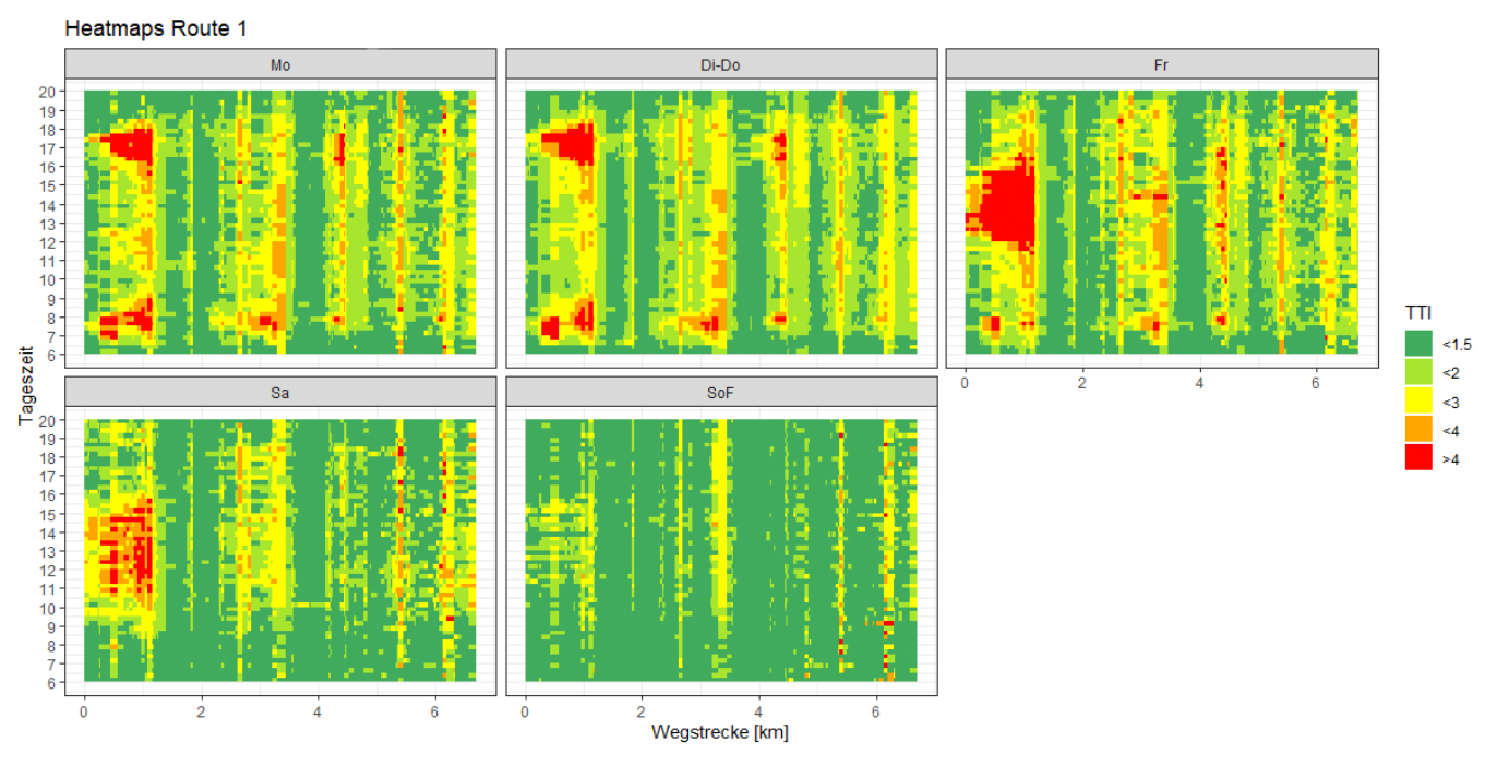
Illustration: Analysis of real journey time losses in local public transport with respect to individual road sections, which can then be represented for example as heat maps. © Salzburg Research
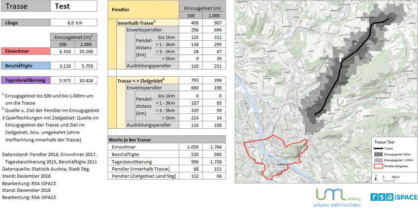
Route Analysis
Planning of pioneering mobility provisions with a focus on commuter traffic
The route analysis service supports the planning of pioneering mobility provisions with a focus on commuter traffic through holistic consideration of corridors/routes (bus, rail, cycle…) with comparable indicators (incl. commuter dynamics, space potential, population structure).
Based on methodology, a data basis and indicators that are standard across Austria, analyses can be performed quickly to facilitate standardised comparison between the routes. To support innovation projects in the cross-border area of urban mobility laboratory zukunftswege.at, targeted development of the service should be undertaken and it should be enriched with further content and technologies (incl. preparation and integration of tourist potential / potential lines to represent potential within routes). It will therefore be possible to align future innovation projects more strongly to the demands of the society, mobility needs, regional requirements, potential or existing provisions and to make statements about possible impact.


Station 4.0
Targeted through innovation projects, developed and supported scientifically
Station 4.0 and the associated services should be available for innovation projects, targeted through innovation projects, developed and supported scientifically.
For the first time, there is an opportunity to generate data from real operation of a Station 4.0 (monitoring) and combine them with planning strategies and tools, to allow value generation for further innovation projects in the area. To this end, approaches from the ULTIMOB model project, such as modelled commuter potential and the “multimodal action plan” (multimodal facilities at hubs), are being developed and enriched with user data. This allows better simulation and planning of innovation projects, to improve the effectiveness of public transport systems (accessibility, public transport improvement, society etc.). Articles are created on further expansion or the planning of additional live laboratory stations in the city of Salzburg and in the federal state of Salzburg.
Traffic Data for Private/Public Transport
Basic mobility data are provided for the areas of the test corridors
The regional authorities provided basic mobility data (from counting stations or the Salzburg traffic computer) for the areas of the test corridors.
By contrast, traffic data for private/public transport service generates speeds and journey times obtained independently from floating car data, as distinct from the basic mobility data, which are referenced on the GIP graph integration platform. For the test corridors, these data from real traffic activity in private/public transport are provided for innovations projects either via a real-time data interface or as historic data packets.
Cooperative Transport Hubs
C-ITS services for transport hubs
C-ITS (cooperative intelligent transport systems) connect transport users and promote transport efficiency and safety. This networked data communication between individual vehicles and between vehicles and the infrastructure allows fast, smart incident management on the road: Disruptions can be identified quickly, and it becomes possible to issue precise warnings to all transport users in the road section.
Salzburg Research offers framework conditions for testing innovation projects:
- Cooperative test hubs: Along a test corridor, three selected transport hubs are developed into cooperative test hubs. This means C-ITS (cooperative ITS) services for innovation projects are provided for these transport hubs via a data interface. These include the C-ITS-capable vehicles as well as messages sent by the transport infrastructure, for example such as traffic light switching times.
- Classified movement trajectories: Furthermore, the selected transport hubs are equipped with additional sensors, with which all traffic movements at the transport hub can be recorded automatically and classified by movement mode (pedestrian, cyclist, motorised private transport, public transport). These classified movement trajectories can be made available either in real time or as historic data.
- Digital image: Moreover, an accurate image or so-called high-definition map of the transport infrastructure at the test hubs is provided (HD map).
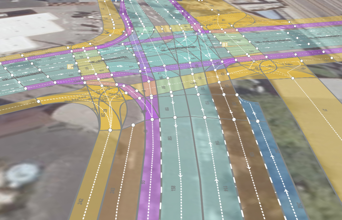
Illustration: HD map of a crossroads in the city of Salzburg, © Orthophoto: basemap.at, processing by Salzburg Research
Walkability
Quality measurement of cycling infrastructure
For the purpose of balanced consideration of the environmental alliance, particular attention should be paid to active mobility. As well as cycle mobility and its infrastructure, pedestrian traffic is given particular consideration within the test environments and in the area around the defined mobility hubs. The focus here is on walkability and therefore on the accessibility including of mobility hubs and central facilities.
Pedestrian traffic is especially important in the context of the first and last mile in public transport. The elements of a walkability index include properties of the pedestrian infrastructure, topography, network density and road safety parameters. The aim is to establish an interoperable, transferable index, which is referenced as an attribute on a corresponding transport graph, can be used for analyses of surroundings and accessibility, and is generally made available for innovation projects in a methodical and data-related way.
Data Infrastructure
Various mobility data can be provided via mobility laboratory zukunftswege.at. On the one hand, these are data collected directly by the respective regional authorities.
These include, for example, count data from automatic traffic counting stations for cycle or car traffic and data about traffic lights in the city of Salzburg. On the other hand, data are also provided about public transport, such as timetable data and any real-time information. There is also access to the road graph of the state of Salzburg and the respective spatial structure data available.
Furthermore, even more specific data are generated about the services within the mobility laboratory in the areas of walking, cycling and car traffic, and these are made available for research projects.
If you are interested in these data sets, please get in touch using our contact form.
